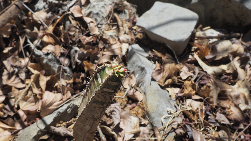


 4 photographs ›
Summary
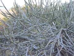
Euphorbia neohumbertii is a species of flowering plant in the family Euphorbiaceae. It is endemic to Madagascar. Its natural habitat is rocky areas. It is threatened by habitat loss.
Quoted from Wikipedia, "Euphorbia neohumbertii", CC BY-SA 4.0.
About the genus · Euphorbia
Euphorbia is a large and diverse genus of flowering plants, commonly called spurge, in the family Euphorbiaceae.
Quoted from Wikipedia, "Euphorbia", CC BY-SA 4.0.
Cultivation
Grouped as a cactus or succulent, listed under the genus Euphorbia in the archetype table, and Kew describes it as “semisucculent subshrub or shrub”.
How this section is made
Each card states this species' habitat figures with their sources, and what two fixed rules read from them; nothing here says what the plant does, wants or tolerates. The rules · the terms.
Group. Listed under the genus Euphorbia in the archetype table, and Kew describes it as “semisucculent subshrub or shrub”. A group is taken only where Kew's description of the species agrees with the table's listing. The table gives no figure and no prose; the cold floor is the habitat's alone.
Climate across the habitat
Natural habitat
How this section is made
Photographs


Photographs: Frank Vincentz, CC BY-SA 3.0, via Wikimedia Commons (2); Michael Wolf (Webseite), CC BY-SA 3.0, via Wikimedia Commons.
Related
Other Euphorbia 400 in the reference
 Euphorbia abdelkuri Abd al Kuri euphorbia Photo: CC BY-SA, Stan Shebs
 Euphorbia abyssinica Abyssinian spurge Photo: CC BY-SA, Frank Vincentz
 Euphorbia acanthothamnos Greek spiny spurge Photo: CC BY, Eleftherios Katsillis
 Euphorbia adenensis Euphorbiaceae Photo: CC BY, Joey Bom
 Euphorbia aeruginosa Miniature Saguaro Photo: CC0, author not stated
 Euphorbia aggregata Pincushion euphorbia Photo: CC BY-SA, Frank Vincentz
 Euphorbia albipollinifera Euphorbiaceae Photo: CC BY-SA, Frank Vincentz
 Euphorbia alfredii Euphorbiaceae Photo: CC BY-SA, Frank Vincentz
 Euphorbia alluaudii Euphorbiaceae Photo: CC BY, amantedarmanin
 Euphorbia ambovombensis Euphorbiaceae Photo: CC BY-SA, Frank Vincentz
 Euphorbia ammak Euphorbiaceae Photo: CC BY-SA, Frank Vincentz
 Euphorbia ampliphylla Euphorbiaceae Photo: CC BY-SA, Medium69 (William Crochot) all 401 ›
Names & registers
Also known as Euphorbia neohumbertii var. neohumbertii. (GBIF Backbone)
The record
Every figure here is derived from public data by a stated rule and names its source; nothing about this species is written for its page by a person or by AI, apart from the marked, credited quotations. How →
Where this page came from built 2026-10-22
gbif.species answeredasked 2026-10-22gbif.synonyms answeredasked 2026-10-22gbif.vernacular answeredasked 2026-10-22names fetched 2026-10-22wcvp.distribution answeredas of 2026-06-04gbif.occurrences answeredas of 2026-10-21GBIF occurrence download https://doi.org/10.15468/dl.hbdw64, of 2026-10-21climate nothing to reportasked 2026-10-22only 2 distinct land cells of the climate grid hold an in-range record placed to within 10 km; three are needed for an envelopewikidata answeredasked 2026-10-22wikipedia answeredasked 2026-10-22inat.photos.wild answeredasked 2026-10-22from iNaturalist's open data of 2026-09-27: research-grade observations with an open-licence photograph, the 24 whose photographs iNaturalist received last (the open data holds no votes); filled 2026-10-22inat.photos.cultivated not askedgbif.media answeredasked 2026-10-22none of the photographs on this page is credited to GBIF: those shown are other sources', and GBIF's were the same photographs or were set aside by the photograph rulescommons answeredasked 2026-10-22openalex not askednot yet asked for this reference; a later fill takes the papers from OpenAlex's snapshotEvery source is recorded as having answered, reported nothing, refused, failed, not been asked, or answered twice where one answer is taken (“not taken: two items answered”), and, for a source asked when this page was built, when: the figures are as the source held them that day; a source read from a file (Kew's World Checklist, a GBIF download) says "as of" the file's day instead; a row carried from an earlier build of the page names that build instead. Only “nothing to report” is ever shown as an absence. Records came from 4 datasets via GBIF.org; each carries its own licence.